Relic point Vietnam
Việt Nam
Hon Chong - Hon Do
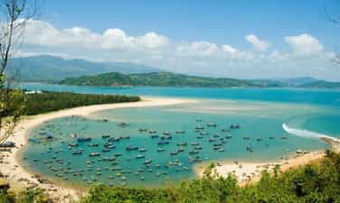
Hon Chong - Hon Do scenic spot is located on the banks of Nha Trang Bay, belonging to Vinh Phuoc and Vinh Tho wards, Nha Trang city. The landscape includes: Hon Chong, Hon Do, and Nha Trang Bay. In 1998, the landscape was ranked national. Hon Chong - Hon Do scenic is formed by the creation of nature. Those are large and small rocks stacked into multiple layers stretching from the foot of La San hill to the East Sea to create an impressive layout in the natural scenery of Nha Trang Bay. There creating interesting images and beautiful and airy natural beaches. The northern stone group is called Hon Chong and a small stone group, lower in the south called Hon Wife. Creator cleverly arranged the stone beach protruding into amazing images such as "Heaven Gate", "Stone arms", "Sea kiss", "Tien Ong" ... have formed folk legends Roll, attractive and humanistic. Legend of "Fisheries and Husbands": There is a poor couple living by coastal fishing. The couple often go out to catch shrimp and fish to feed their families. One day, the big breeze drifted their boats here. Large stones and big waves engulf the small boat. The boat broke down and swept his wife away, the husband rushed to save his wife. But every time he pulled his wife close to the shore, the large waves were stamped into the rock and pushed the couple away. The husband tried to save his wife, one hand clinging to the cliff, one hand holding the beloved wife. But the intense large waves engulfed the fishermen and they died together. Today, at Hon Chong scenic, there is still a large rock imprinted with five fingers' hands of the husband, demonstrating the passionate, profound and loyal couple. The legend of the giant giant Du Son Thuy: In the old days in the world full of fragrant flowers, strange and poetic scenery, so the fairies often went to the naked naked. The fairies play chess, female fairies playing, the giants go to sightseeing ... Every occasion of the earth, the fairies are freely joking and enjoying, taking off the Siamese soaked in the cool spring. Or expose himself to the blue coast of the murmur ... One day a giant was looking for beautiful, strange scenery, accidentally he saw the fairies soaked in the clear blue sea. Enjoying, he walked down and almost fell. While playing with, the giant clinging to the rock, making the mountain rocks, scattered everywhere, a stone with his fingerprints rolling out to stay on the pile of the island, and the stone with his footprints lying down on the stream Tien (Dien Khanh). Today, the stone imprinted with the fingerprints remains and becomes the evidence of nature about the giant giant bewildered to see the fairies. And the beach where the fairies used to be folk was called Co Tien beach not far from Hon Chong. About 100m from Hon Chong to the south is Hon Toi, small and located in a more discreet position. From a distance, the wife of the wife is like a faithful wife hugging her child to sit and petrified, waiting for her husband to go out. There are also people who imagine that the cuddling scene of the faithful wife. From Hon Wife, looking to Hon Chong looks like a new chubby chicken lying, head towards the mainland. About 300m from Hon Chong to the southeast is Hon Do. The name of the Red Hon is derived from the phenomenon of stones with redness every time the sun shines down here. On the small island still preserves the natural and romantic natural scenery. Those are the red color of the scenes of ti golf, the white color of porcelain flowers by the large cliffs. In the future this will be an attractive destination for you when coming to Nha Trang, walking on a small island just a few hundred meters from the mainland. Standing in Hon Chong - Hon Do watching Co Tien mountain is located in the north, on the banks of Nha Trang Bay is an interesting thing when you come to Tang - Khanh Hoa. At sunset and when the yellow sunshine hugged the mountain of Co Tien, the mountain made the mountain more brilliant and attractive. No need to imagine many customers can also see the image of the young girl full of vitality lying on Nha Trang Bay. The hair went smoothly to the sea, the chubby face, the full chest and the small waist leaned by the beach. Far away in front of Hon Chong is Hon Rua and Yen Island as money and accents for visitors to see Nha Trang Bay. The southeast is Hon Tre Island like the wall keeping Nha Trang Bay always quiet. On the island is Vinpearl Land tourist area - Hon Ngoc Viet. Source of the Ministry of Culture, Sports and Tourism.
Khanh Hoa
3926 view
Rating : National relics.
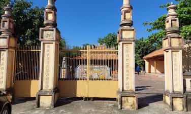
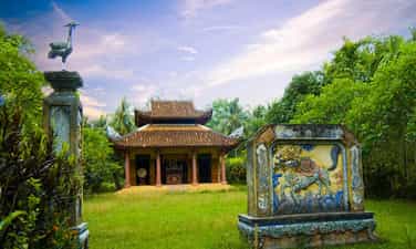
Phu Cang communal house
Phu Cang communal house is the name associated with the name of Phu Cang village (Phu Cang village) in Van Phu commune, Van Ninh district, Khanh Hoa province. The communal house was built here by Vietnamese residents in the late seventeenth century and early eighteenth century to worship the village tutelary god, worshiping Thien Y Thanh Mau, Tien Hien, Hau Hien (those who have publicly reclaim the land. belt, people, establishing hamlets, creating villages ...) and worshiping martyrs who were the people of the village sacrificed in the two wars against the French colonialists and the American imperialists. The communal house was built on a high position, wide at the beginning of the village. The communal house is located in a fairly large campus, on a high area, an area of about 1,700m2, turning to the northeast. From the outside, the monument includes architectural works: Nghi Mon (Gate), Phong Phong, Dai Dinh, Dong Dynasty, Western Dynasty. Dai Dinh was built in a traditional structure with a wooden frame with 04 large wooden columns in the middle that looks very superficial, firmly supporting the roof system with a traditional architecture of Khanh Hoa. Along with the yin and yang tile roof, the door system is in the style of "upstream" and the mascot images: Mesopotamia of the Chau Chau, the nghe, the bat on the top Country. Those are the unique ancient architectural values of the Vietnamese communal house. In addition to the architectural element, it has been reserved quite complete for hundreds of years of many variables, the communal house also has a hallmark of revolutionary history through the periods of resistance against the French colonialists and American imperialism invading comb. In particular, this is one of the typical relics of the early August Revolution in 1945 in Khanh Hoa province in general and Van Ninh district in particular. In 1885, in response to Can Vuong against the French of Ham Nghi King, the Can Vuong movement in Khanh Hoa was stood up by the patriots and writers to gather the masses against the French. The leader of the movement is Binh Tay General Trinh Phong, and Deputy General - the Northern Governor of the Road. In Van Ninh and Ninh Hoa with the command of the Governor of Tran Duong, he attacked France many horrific phen and Dinh Phu Cang was the gathering place for the army to practice to fight the French from Deo Ca. Because the French colonialists were equipped with state -of -the -art weapons, and the insurgents mainly use rudimentary weapons, the force of the army was weakened and was suppressed by the French colonialists, the insurgents had to retreat. In 1886, the French did not catch Tran Duong, so he tried to suppress the people and his family members, Tran Duong went to the goods so that the French colonialists did not suppress the people. They killed him and beheaded the market to threaten the patriotic movement. After he died, the people brought his card to worship at Phu Cang Dinh with a respectful gratitude to the local hero. In 1930, the Communist Party of Vietnam was born leading the patriotic revolutionary movement of our people. In 1936, a number of Communist Party members were operating in their homeland, including Mr. Mai Duong, gathering party members in Phu Cang communal house to establish the first Party cell in Van Ninh district. From here, Phu Cang communal house is the basis of the Party Committee of Van Ninh district during the resistance war against the French until the national independence. In 1945, in preparation for the uprising to win the government to the people, the Viet Minh organization here gathered young people to practice at night at the yard, some guarded and alarmed people when France patrol . Also at the communal house is the venue for meeting and studying 10 policies of Viet Minh's Front, thereby enlightenment to the people about revolutionary ideology, patriotism, love for the homeland and the responsibility of the entire people to fight the French. national liberation. Since then, the spirit of the revolutionary movement has increased. When the opportunity was ripe, on August 14, 1945, the Viet Minh Front in Van Ninh gathered the people of Van Ninh to return to Phu Cang communal house, using the drum of the communal house to make a signal of the people who launched the most people to stand up Gain power. In the period of 1945 - 1954, Phu Cang communal house was still a training place for self -defense and local guerrilla, strengthening the front of Nha Trang - Khanh Hoa 101 day and night against the French (October 23, 1945 - February 2 /1946) and supplement forces to the 365 unit of the inter -region. This force has participated in brave battle to create a glorious battle, kill tanks and armored vehicles of French in Co Ma pass. During the resistance war against the US to save the country, Phu Cang communal house was still a place associated with the local revolution. It is the place to raise revolutionary cadres, receive wounded soldiers of the Lunar New Year battle in 1968. In the years 1971 - 1972, Phu Cang communal house was the revolutionary base of comrades at the Geography base Base Ban Ban network (Ninh Hoa - Van Ninh), or from Van Ninh to Co Ma Pass to Phu Yen. With the revolutionary struggle traditions of the local people associated with the communal house, especially the place to launch the local people standing up to uprooting the authorities to win the people in the earliest people in Khanh Hoa, In 1998, the Ministry of Culture and Information (now the Ministry of Culture, Sports and Tourism) ranked Phu Cang Dinh Dinh as a historical - national cultural relic. Source of the Ministry of Culture, Sports and Tourism.
Khanh Hoa
4183 view
Rating : National relics.
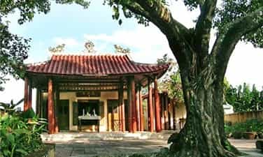
Trinh Phong temple
Trinh Phong was born in Phu Vinh village, Xuong Ha, Vinh Xuong district (now Phu Vinh village, Vinh Thanh commune, Nha Trang city). As a child, he was a smart, good study, passed a bachelor's degree in Vo (1864) and was held in the Nguyen Nam Dynasty by the Nguyen Dynasty in Quang Nam. Witnessing the miserable people, the court divided the sects under the invasion of the French colonialists, he came from the mandarins, returned to his homeland to wait for the opportunity to chase the invaders. Responding to the call of King Ham Nghi through "Can Vuong", the uprising "Binh Tay to save the National Union" led by Trinh Phong in 1885 reclaimed Dien Khanh citadel and owned the majority of Khanh Hoa province. In 1886, before the enemy's strength, the Can Vuong movement in Khanh Hoa was extinguished but the spirit of heroic and indomitable fighting was left in the hearts of the local people a particularly deep affection. Trinh Phong and two other leaders, Tran Duong and Nguyen Khanh were worshiped as "Khanh Hoa Tam Kiet". In the photo, the statue of Trinh Phong was placed in the middle of the worship in the temple. Trinh Phong Temple relics have a total area of more than 639 m2, located on the side of 23/10, surrounded by many houses, just below the canopy of double oil tree over 350 years old. The temple was built in 1886, associated with the story handed down in folk. The story said that when the Binh Tay General Trinh Phong lost his battle, the enemy washead him and brought it back to Dien Khanh to Thi Uy. After that, his level was buried by his relatives, but was monitored by the enemy, hanging a cloth bag holding his head on the dust next to the double oil tree. The next day, the locals discovered and brought their heads to burial and worshiped but did not know who the unfortunate was. It was not until a man who "went to the field" to claim to be Trinh Phong was murdered by the enemy, his head, buried by the people, created a worship, now please thank you. Since then, small Am is called Trinh Phong temple or Cay Dau Temple. After that, Trinh Phong Temple was given the 13th Thai King (1901) to the "Great Germany", then in the 9th King of Khai Dinh (1924), he continued to confer his ordination with the beauty " Bao Trung Hung Linh Pho is the main ", remembering the hero because the country forgot. The temple is built in the architectural style of a two -wing space, three doors are designed in the upper style, the wooden frame structure has the characteristic of traditional monuments in Khanh Hoa. The main hall hung a wooden diaphragm that engraved with Han Nom character "Van An Temple". The door system is designed in the upstream style. In the middle of Bai Duong, a simple wooden altar but showing ancient and solemn. Over time, the temple has passed many times to be renovated and embellished. Four square wooden columns support the roof of the main hall, on the body of the column carved two pairs of couplets in Han Nom characters and painted in the golden lacquer, above the carved pattern of flowers and leaves. Inside the main hall hung two pairs of sentences to praise Trinh Phong's merit. Between the main hall placed the Council's altar, the two sides placed a pair of fabric parasols, above the altar hanging a shock. Adjacent to the wall behind is a wooden church that is meticulously carved and engraved with the "god". And the double oil tree is about 30m high, 4-5 people hugging and standing next to the side protects Trinh Phong temple through many ups and downs of history. According to the seniors, no one knows how old the oil tree is, but according to the record, Lord Nguyen Phuc Tan let Cai Co Hung Ngoc almost reclaim the forest and expand the border in 1653 to see the huge double oil tree beyond surpassing Outstanding between the old forest, the Co -ordered the order not to cut down to create shade. In 2016, double oil trees were recognized as a Vietnamese heritage tree. Trinh Phong temple was recognized by the Ministry of Culture, Sports and Tourism as a national historical monument in 1991. Source of the Ministry of Culture, Sports and Tourism.
Khanh Hoa
4480 view
Rating : National relics.
Dinh Chien Dan
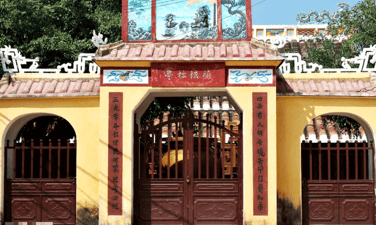
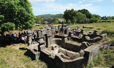
Chien Dan is one of the most ancient communal architectural works in Quang Nam. Currently, the communal house is located in Dan Trung village, Tam Dan commune, Phu Ninh district, less than 1km from National Highway 1A. According to historical documents, the old fried land of Ha Dong district, sublimated. In order to commemorate the merits of the ancestors, the gentle, Hau Hien has publicly painted the jelly to set up the flock; People in the village, in the commune at that time, together built the flock of the flock with a superficial scale and named the "communal house" in a high, flat area. The main communal house is built in the most shaped shape, the face turned to the southeast, the roof of the yin and yang tile roof, the two ends of the roof decorated with sophisticated patterns with the image of "Mesopotamia", the porch covered with two unicorns . The entire campus of the communal house is 1,500m², the main house is 500m² wide, with enough room for over 100 people. The communal house consists of 5 spaces, 2 wings with 30 jackfruit wood columns bigger than an adult bracelet, 3 compartments between used as a place of worship. The main face is a row of 6 columns separated from the temple according to the layout of the three chims. The beams above the top of the three spaces (through the upper hip connecting the two sets of trusses). In the communal house, the lawsuit was exquisitely carved and flexible by the artisans of Moc Van Ha village, Tam Thanh commune, Phu Ninh district. A wooden column is restored. Since construction up to now, the communal house has undergone many remodeling, most recently in 1996 and 2006 but the original elements of the communal house have been preserved intact of an ancient architectural work. According to the legend and the narrative of the elderly people living near the Chien Dan communal house, when King Le Thanh Tong went to conquer, the Southern Binh Dinh, the king used the flock to rest and make suitable decisions To win. Chien Chien Dan is ranked as a national architectural and artistic monument (Decision No. 39/2002/Decision -The Culture and Culture of December 30, 2002 of the Ministry of Culture and Information). Calendar, people open the communal house to commemorate their father's gratitude. Source of Quang Nam Electronic Information Portal.
Da Nang
4241 view
Rating : National relics.
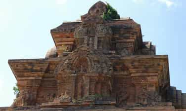
Binh Lam Tower
Binh Lam Tower is an ancient Champa tower in Binh Lam village, Phuoc Hoa commune, Tuy Phuoc district, 22km from Quy Nhon City. This is a relatively special tower in Binh Dinh, because unlike other towers located on the hill, the Binh Lam tower is located right in the plain and as immersed in nature and the surrounding residential area. The tower has a square jar, each side is about 10m, about 20m high is divided into 3 floors, delicate pattern decoration, architecture in harmony with the lines that are both stared and strong. The tower was ranked as an architectural monument in 1993. Source of electronic portal of Binh Dinh province.
Gia Lai
4561 view
Rating : National relics.
Dao Duy Tu Temple
Dao Duy Tu (1572-1634) is a historical figure of the 17th century, a person who proved excellent in many economic, political, military and cultural fields. Dao Duy Tu was born in 1572 in Tinh Gia government, Thanh Hoa (ie Tinh Gia district, Thanh Hoa today). As a master of history books, physics and tactics, but due to being restrained under the Le-Trinh dynasty, he did not allow him to enter the gate (a bachelor's degree) because he came from a dual family. species), so Mr. Uat Chi left in Dang Trong to start a career. It was in 1625, when Dao Duy Tu was 53 years old. When he first entered the South, due to many difficulties in his life, he had to hide himself at a buffalo for the rich family to wish Trinh Long in Bo De commune (now in Bong Son town, Hoai Nhon district in Binh Dinh province). Because of the talent of Dao Duy Tu, the examination of Tran Duc Hoa had married his daughter and advocated Dao Duy Tu for Lord Sai Nguyen Phuc Nguyen (Quan Ly Tran Duc Hoa (also known as Cong District Cong). And also brothers and sisters with Lord Nguyen Phuc Nguyen (also known as Thuy district). Lord Nguyen returned to the military, political, cultural organization and successfully confronted Trinh Lord in Dang Ngoai and was liked by Lord Sam as Ngoi Long Gia Cat (Khong Minh). Products, poetry and the ancestor of the art of drama, famous for the two songs, "Ngoi Long Cuong Van" and "Tu Dung Van". Co ", considered one of the two sets of military art books (the other work is" weak soldiers ") of Vietnamese people. He lost the year of Giap Tuat (1634), aged 62 years old. After dying, Lord Sinh was awarded "The Youth Union of Duc Cong Than, especially the Golden Golden Golden Loc Phu" for worship in Thai Mieu. Coming to the Minh Mang dynasty, Dao Duy Tu was ordained the title of "University of Sy - Master Hoang Quoc Cong" and set up a temple at his residence - now Ngoc Son village, Hoai Thanh Tay commune, Hoai Nhon district, province, province Pacify. The temple today retains its campus and is still worshiped and preserved by the local people and the local people. On October 15, 1994, Dao Duy Tu temple area was recognized as a national historical monument. Source of electronic portal of Hoai Nhon town, Binh Dinh province.
Gia Lai
4854 view
Rating : National relics.
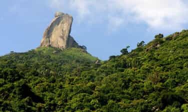
The monument of rocky mountain
Da Bia Mountain is located on Deo Ca mountain range, south of Dong Hoa district. 706m high mountain, east with Ba Ba Hon close to the sea, the foot of the western mountain is National Highway 1A, north with Dong Son mountain, the foot of the southern mountain borders Vung Ro. Stone ridge is very steep with many rocky rocks, overgrown trees, roads to the top are quite hard. On it a tall block of stone is called beer stone. Depending on the perspective, you can see stone beer with different physique. At the top of the mountain, there is a high slope, seeing beer stone like a lion lying down the ribs. At the Hao Son junction - Han Dam looked up, stone beer was like Nhan tower. From Bai Xep - Bai Bang (Hoa Tam commune) looks at, stone stone is like a sitting. At Hoa Tam Truong, looking at stone like a standing Buddha, it can also be said that the monk is down the mountain. At the foot of the mountain, there is Tien beach. In Phu Bien Tap Luc, Le Qui Don wrote: “Da Bia Mountain in Phu Yen is the precursor of the boundaries with Chiem Thanh, the mountain is very far away, the watershed of the coast. This mountain is higher than another mountain. When Holy Tong beat Chiem Thanh to take this land into Quang Nam, set up the old Chiem Thanh lineage, Phong for the land to return to the west, sculpted the peak of the mountain to set up the boundary, his back turned to the north, facing towards, facing towards, facing towards, facing toward Nam, for a long time, the word has been worn out ”. The book of Dai Nam unanimously wrote: “Considering the book of Luc Trinh Chi Chi of Tran Cong Hien, the paragraph is that: This mountain has a limb to the sea, dividing two streams of water, plants and plants, there is a large stone spinning. East head as shown. When King Le Thanh Tong went to fight Chiem Thanh through that mountain, sadly lamented: "Since the time of the early sky, the boundary was divided, because of the inverse of heaven, it had to suffer from heaven." The king made the word touch on the rock. Did King Le Thanh Tong are engraved on the rocky mountain? People still consider it a legend, marking the historical turning point of the land of Phu Yen. Because in Dai Viet historian, there was a journal of the King's Nam Chinh record as follows: "On the first day of March of the New Year of the Rabbit, the 2nd Rabbit, the 2nd day, went down to the army." In 1937, there was a survey of the stele mountain of Tri Tuy Hoa government at that time Nguyen Van Tho. In recent years, there are surveys of young people and students of Phu Yen, they have not found any traces. Rock Mountain (also known as Thach Bi Son) is 706m high, majestic in the north of Ca Deo Rang. On the top of the mountain is a giant 76m high rock block, with strange shapes, early in the morning or in the afternoon, there is often white clouds covered around, when hidden when appearing. Bia Da mountain was recognized as a national landscape monument in 2008. Source of the portal of Phu Yen province.
Dak Lak
4579 view
Rating : National relics.
Xuan Dai Bay
Xuan Dai Bay is located about 45km from Tuy Hoa city to the north with a green area, charming painted paint contains many important historical events related to Phu Yen land. With an area of more than 13,000 hectares, Xuan Dai Bay is located in Song Cau and Tuy An districts. Surrounding the bay are high mountains and also part of the Truong Son mountain range stabbed straight to the sea. In the east there is Xuan Thinh peninsula starting from the Luong Luong Pass to the East - South hugging Xuan Dai Bay. Xuan Dai Bay is also a place to witness many important events associated with the 400 -year history of establishment and development of Phu Yen. At the end of the sixteenth century, the first Vietnamese followed Mr. Luong Van Chanh to Phu Yen to choose favorable lands along the estuaries and estuaries to make the living area. These are the areas of Cu Mong, Ba Dai, Da Dien and Da Nong. A document dating back to 1597, stored at Luong Van Chanh Temple, said: From the paint area, the bottom is to the estuaries, together to set up houses, exploit wasteland into garden fields, go through 3 cases, pay tax as usual ”. The Ba Dai area at that time was included in Xuan Dai Bay and lowering the Cai River belonging to Tuy An today. This area has both fertile farming area thanks to the alluvium of Cai river, and has a airtight bay that is convenient for anchoring fishing boats to catch seafood. From the first settlements, the Vietnamese people expanded their living areas, mastering the sea, plains and large mountains in the west, turning this large area to become rich and busy. . It was also an important basis for the early seventeenth century, the area of Xuan Dai Bay became the administrative center of Phu Yen. In 1629, the capital of Phu Yen, Hoi Phu, was built at Tien Chau gate right on the banks of Xuan Dai Bay, the place where the old historian was built, there was a mountain of Xuan Dai nearby. During the fighting period between the Tay Son Dynasty and the Nguyen Dynasty, Xuan Dai Bay became a battlefield with many major naval battles. In June 1775, after the Tay Son army owned Phu Yen land, the general of Lord Nguyen, Tong Phuoc Hiep, commanded more than two thousand troops to regain this land. The army of Tong Phuoc Hiep mainly stations in the area of Hoi Phu and Xuan Dai Bay. In order to deal with the army of Tong Phuoc Hiep, General Tay Son, Nguyen Hue at that time, was only 23 years old, brought a army along the mountain road in La Hien in combination with the on -site force and suddenly attacked Tong Phuoc Hiep's army. Quickly disintegrating, Xuan Dai Bay became an important Marine base of the Tay Son family. By the last years of the eighteenth century, when the forces were growing, Nguyen Anh often pulled troops from the south to harass Tay Son and Xuan Dai Bay to become a fierce fighting battlefield. At the end of the nineteenth century, the uprising responded to the Can Vuong movement led by Le Thanh Phuong in Phu Yen. In June 1897, the expeditionary army under the command of Chevreux, Tirant and Tran Ba Loc landed in Xuan Dai Bay to suppress the uprising. The base of the insurgency stationed in Xuan Dai Bay led by Bui Bui was lost, two weeks later the uprising was extinguished. In April 1945 the Japanese Navy ships entered Xuan Dai Bay to conquer to make a stepping pedal into the mainland, but were sinked by the Allied aircraft in the middle of the bay. The hull sinks in the deep water, leaving only the flagpole and the observatory. Until the late 80s of the early 90s of the twentieth century, there were still traces in the Wing Chun. Xuan Dai Bay is also the place where the first diplomatic activity between Vietnam and the United States. Xuan Dai Bay area is also the homeland of celebrity Dao Tri. He used to serve under the dynasties of Minh Mang, Thieu Tri and Tu Duc. Dao Tri once held the positions of the capital and General Ha Ninh (Hanoi, Bac Ninh). So far, historical events have gradually retreated to the past, but the evidence of a heroic time still saved the seal in the area of Xuan Dai Bay. Experiencing many ups and downs of history, Xuan Dai Bay is now entering a new period of development, commensurate with the inherent strengths of a national scenic monument. On November 20, 2011, Xuan Dai Phu Yen Bay was ranked by the Ministry of Culture, Sports and Tourism. Source of the portal of Phu Yen province.
Dak Lak
4263 view
Rating : National relics.
Tomb relics and location of Dao Tri temple
The tomb and location of Dao Tri temple is a testimony of a historical celebrity of Phu Yen land, participating in important historical events of the Vietnamese nation in the nineteenth century. Dao Tri was born in 1799, died in 1879, in Vung De, Tan Thanh Quarter, Xuan Dai Ward, Song Cau Town, Phu Yen Province. He came from a fisherman's family, specializing in living by fishing. But with the smart and intelligent nature, he became one of the most advanced martial arts officials in the Nguyen army system; In turn, all three dynasties of the Nguyen King, Minh Mang, Thieu Tri and Tu Duc. In the 21st year of Tu Duc (1868), Dao Tri was promoted to the army of the capital. Dao Tri is both a martial arts martial arts with illustrious feats, and a great god who has a lot of merits in ruling and educating the people, and being praised by King Tu Duc, giving a reward of Kim Bai with the word " The virtue, the people ”, wrongly, the mandarin writes the epitaph recorded the merit of the merit ... Dao Tri died at the age of 80 years old (1878) in his hometown of Tan Thanh village and was worshiped by Descendants. Currently, Descendants of Dao Tri in Tan Thanh village is the last is the 5th generation, Mr. Dao Van is the oldest. Mo Dao Tri is now located behind Tan Thanh village, on the northeast of Hon Vung mountain, with a height of 20m above the sea surface, about 300m from Highway 1 A. The tomb faces the north, the scale of building the superficial place, the tomb and the fence surrounding the surrounding fence, the tomb covered with elephant -shaped mushrooms, the front has a room ... , about 1km from the grave to the north. The temple of Dao Tri was devastated by the war, the remaining traces had only an area of 7.2 core 8 meters and a phosphorus project was covered with moss with time ... With those values on July 2, 2015, the tomb and location of Dao Tri Temple has been ranked as a national monument under Decision No. 2247/Decision -Culture and Sports Culture Tourism Source of the portal of Phu Yen province.
Dak Lak
4572 view
Rating : National relics.
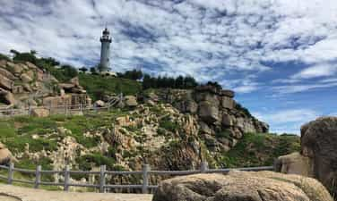
Landscape Area Bai Mon - Mui Dai Lanh
The landscape of Bai Mon - Mui Dai Lanh is located in Dong Be village, Hoa Tam commune, Dong Hoa district, Phu Yen province), about 35km southeast of Tuy Hoa (Phu Yen). Characteristics: This is a place to converge many beauty of nature with forests, sea, streams and hills. There is also a night lighthouse to help boats and boats back and forth on the sea and into Vung Ro Bay. Dai Lanh's tip was created by Dai Lanh mountain range - a branch of the Truong Son mountain range, stabbing into the East Sea. The Great Cape was discovered by a French general Varella at the end of the 19th century. Varella realized the important role of the Great Cape on the international map. Therefore, on the old map it is called Cap Varella (Varella's tip). The special feature of Dai Lanh's nose is that it looks like a mountain like an island because there is a fresh water stream separating it out of the mainland but actually it island. The landscape in Dai Lanh mountain has been listed as beautiful landscapes of Vietnam. In 1836, King Minh Mang showed the image of Dai Lanh mountain in Tuyen Dinh - one of the 9 bronze peaks placed at The temple in the inner city of Hue (Thua Thien - Hue). In 1853, during the reign of King Tu Duc, the Great Lanh was in the national dictionary compiled by the court. Local people also call Dai Lanh Mui Mui Dien, because on the top there is a lighthouse about 26m high, at an altitude of 100m above sea level and can signal light goes away from 27 nautical miles. The lighthouse has a cylindrical shape with an average diameter of nearly 5m, inside the pillar is installed 108 wooden spiral stairs to the top. This is one of 8 lighthouses dating back over 100 years out of 79 lighthouses operating in our country. The lighthouse was built by the French in 1890 with the aim of orientation for boats to operate on the sea and enter Vung Ro Bay. The light of the sea was operating for 55 years, and in 1961, it was previously recovered by the Saigon government. However, the lighthouse has not been long, it must be paused because the Great Cape is located in the Eastern base area of the revolution, which is the corridor to welcome numbers. In order to prevent the revolutionary supply route into Vung Ro, the United States bombed the mountains of Vung Ro Bay area, destroying the whole lighthouse station. In August 1996, the State repaired, renovated and the lighthouse officially operated in 1997. At the foot of Dai Lanh's nose is Bai Mon. This is a pristine beach, with a shaped moon with a coastline about 400m long, comfortable slope, fine white sand, crystal clear water. In the west of Bai Mon, there is a fresh water stream. After creeping through many cliffs and primeval forests of the North Pass, this stream flowed across the beach and then poured into the vast ocean. The delicate coordination between nature and the people at Dai Lanh - Bai Mon has created a beautiful landscape complex known to many domestic and international magazines, really the valuable asset of Phu Yen province. In August 2008, the Ministry of Culture, Sports and Tourism issued Decision No. 67/2008/Decision -The Culture and Sports Culture, Ranking of Bai Mon - Mui Dai Lanh landscape (Mui Dien) is a national monument. Source of the portal of Phu Yen province.
Dak Lak
4220 view
Rating : National relics.